


Six main components make up what we call weather, temperature, humidity, atmospheric pressure, wind, cloud formation, and rain.
Climate is the long-term pattern of weather conditions in any given area. It affects which foods we can grow/raise, the clothes we wear, the building materials we use, flora, fauna, wildlife, and the likelihood of a major weather event.
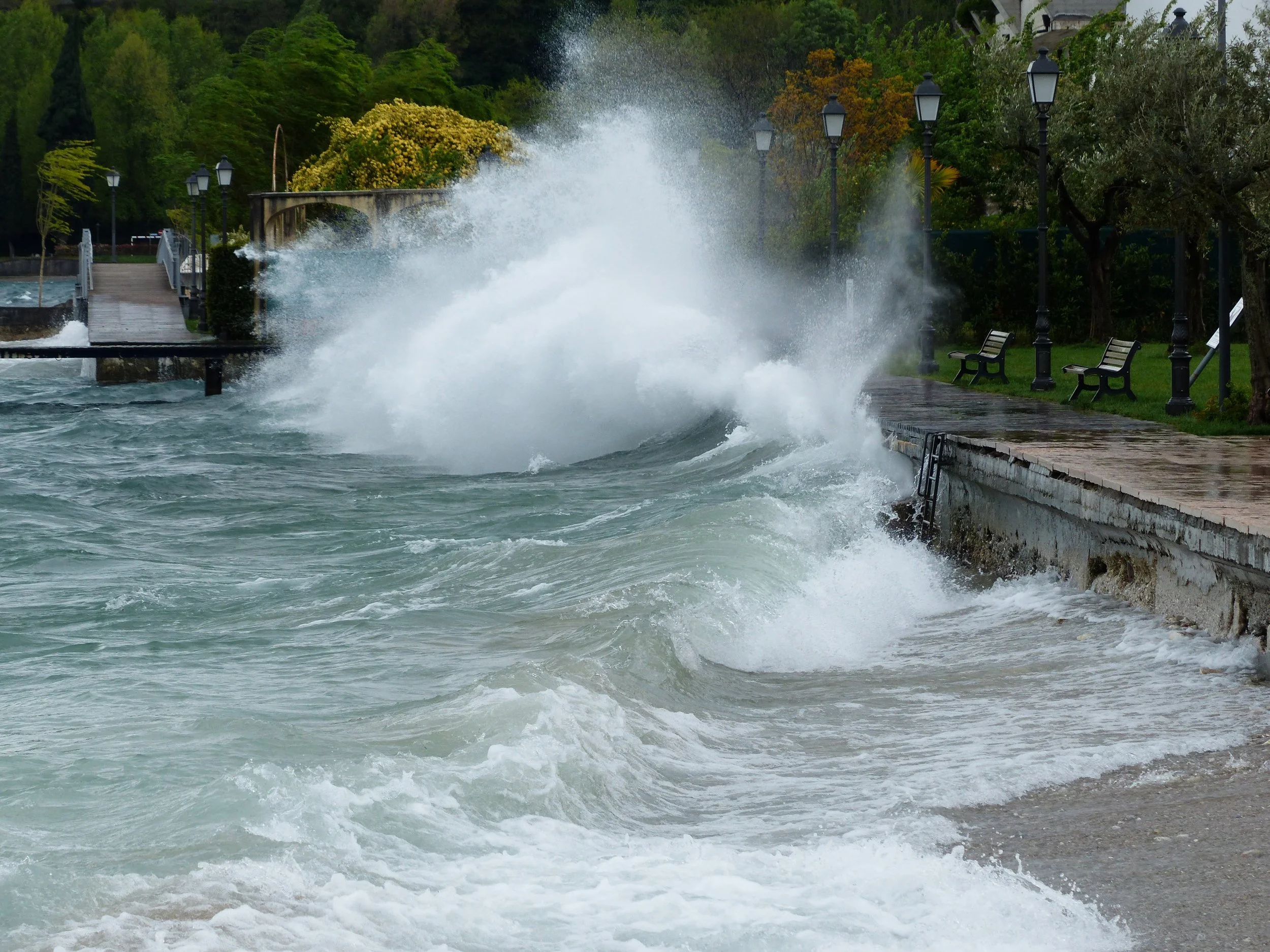
Sudden changes or imbalances can be catastrophic. Weather is often unpredictable. Sometimes it goes rogue.
Heavy winds, rain, lightning, bitter cold, or scorching heat can cause mudslides, flooding, fires, downed trees, and powerlines. During major weather events such as earthquakes, tropical cyclones, wildfires, tornados, or volcanic eruptions, roads and bridges can become inaccessible.
Overburdened power grids, crumbling infrastructure, and limited resources can delay lifesaving weather alerts and disaster response.
Security concerns about looting, hoarding, and maintaining safety at shelters and evacuation sites, safe drinking water and food, and emergency medical services must be addressed while also trying to coordinate the logistics of rescue operations to save lives in imminent danger, identify casualties, and prevent the spread of disease from raw sewage or contaminated water.
Add to that the need to feed and house first responders. The list seems endless and impossible, but despite the difficulties heroes emerge, lives are saved, and communities rebuild after the first wave of heroes move on to help with the next emergency.
Heroes around the world risk or in many cases sacrifice their own lives to save others in weather-related emergencies. I could never acknowledge everyone. Thank you to all the heroes and unsung heroes. May your courage and sacrifice live on and inspire others.
What are some of the major natural disasters that have occurred around the world in the last 150 years?
The Johnstown Flood 1889:
The South Fork Dam located fourteen miles upstream from Johnstown Pennsylvania ruptured after several days of heavy rains releasing 14.55 million cubic meters of water. The flood killed 2208 people.
Elias Unger assembled a group of volunteers to try to save the face of the dam by unclogging the spillway where an iron gate and a fishing trap were lodged with other debris. Other men began digging ditches at the lowest points of the dam to hold the overflowing water and alleviate pressure on the weakest part of the dam. When that didn’t work, they tried piling rocks on the dam to reinforce the crumbling wall.
Unger instructed John Parke to send two warnings via telegraph from South Fork to Johnstown. Parke entrusted the task to another man. The messages weren’t delivered to the Johnstown authorities because there had been several false reports of floods and the dam collapsing in the past. Someone decided it was a prank.
After the dam collapsed Lake Conemaugh emptied in a little over an hour. Most of the town of South Fork was spared because it was on higher ground. The waters flowed downhill toward Mineral Point, Woodvale, and East Conemaugh.
Railyard engineer John Hess spotted the approaching flood. He threw his locomotive in reverse and headed backwards to East Conemaugh blowing the train’s whistle. His warning saved many people who managed to run to higher ground. The flood waters pushed the locomotive from the track, Hess survived; fifty people died including the twenty-five passengers who were stranded on other trains in the village.
Before reaching Johnstown, the flood hit the Cambria Ironworks in Woodvale sweeping up railroad cars. Next it hit the Gautier Wire Works causing boilers to explode. Miles of barbed wire became entangled with other debris headed toward Johnstown. Three hundred-fourteen people in Woodvale from a population of 1,100 were killed.
Fifty-seven minutes after the dam failed, the flood reached Johnstown. The water had picked up speed and was filled with deadly debris – pieces of downed trees, houses, factories, and farm animals. When the debris hit the Stone Bridge, it started a fire. Many people trapped in the water by the debris burned to death. The fire burned for three days. When the flood waters finally receded, the pile of debris at the bridge covered thirty acres and reached seventy-feet high.
Clara Barton supervised fifty volunteers and coordinated the American Red Cross disaster relief effort. Help came from all over the U.S. and eighteen foreign countries. In addition to losing loved ones, their homes, and their jobs, many survivors faced an uphill legal battle to recover damages from the dam’s owners.
The 20th century American Tort Law was created to allow in some circumstances, strict liability instead of fault-based liability.
The Galveston Hurricane 1900:
The Galveston Hurricane is also known as Hurricane One, the Great Galveston Hurricane, the Great Storm of 1900, the 1900 Storm, and the Galveston Flood. Estimated causalities were between 6,000 and 12,000. Official estimates set the number at 8,000. Waters surged between eight and twelve feet during the hurricane. Seven thousand buildings including 3636 homes were destroyed. Ten thousand people were left homeless.
Before the hurricane Galveston was one of the largest cotton ports in the nation. It was the center of trade along the Gulf of Mexico in Texas. Popular for its beaches and easy access by rail, it was home to the first medical college and the first school for nursing in Texas.
On September 4, the Galveston weather bureau began receiving warnings from the U.S. Weather Bureau in Washington D.C. about a tropical disturbance, the accepted euphemism for a hurricane or a tornado.
After the Spanish American War, Willis Luther Moore, the director of the Washington Weather Bureau implemented a policy to block telegraphs from Cuban meteorologists at the world renown meteorological observatory in Havana. Moore also banned local Weather Bureau offices from issuing storm warnings without authorization from the central office.
Forecasters in Washington determined the storm would turn and hit Florida between Cedar Key and Miami. They were the only locations to receive warnings. By the next day, a hurricane watch was in effect from Cedar Key to Savannah, Georgia. Storm warnings were issued from Charleston, South Carolina to Kitty Hawk, North Carolina and from Pensacola, Florida to New Orleans, Louisiana. Cuban meteorologists insisted the hurricane was headed west toward Texas.
The tropical storm which started in Antigua on August 30, caused rains and high winds in Puerto Rico, and flooding in Jamaica. It passed over Cuba causing heavy rainfall and flooding and destroyed crops in Trinidad.
Galveston residents ignored water swells and cloudy weather. Few people evacuated when storm clouds rolled in.
The Great Galveston hurricane made landfall on September 8, 1900, with estimated wind speeds of over 140 miles per hour. Many deaths could have been prevented if American meteorologists hadn’t ignored warnings from Cuban meteorologists.
Galveston meteorologists and city officials also underestimated the possibility of hurricanes striking the city when they decided building seawalls to protect the city would an unnecessary expenditure.
The Yangzi River Flood 1931:
Historians estimate around 140,000 people drowned or were crushed by heavy debris. Famine and disease from the devastation brought the death toll to around two million with over 52 million lives impacted by the damage. Many became refugees. The flood occurred during a time of political instability and conflict. The government which had diverted resources away from maintaining infrastructure to concentrate on establishing order and control responded poorly to the disaster. After the Chinese Civil War, the government began to focus on infrastructure and made significant improvements around the Yangzi River. The 1998 Yangzi River Flood was larger than the 1931 flood, but thanks to better infrastructure and government preparedness. There were only 4,150 deaths.
The Bhola Tropical Cyclone 1970:
Hurricanes and typhoons are both tropical cyclones. Storms taking place in North America and parts of the North Pacific are called hurricanes. In the northwest Pacific they are called typhoons, and in the South Pacific and Indian Ocean they are cyclones or tropical cyclones.
The Bhola cyclone struck Northeastern India (West Bengal) and former East Pakistan (now called Bangladesh). An estimated 300,000 – 500,000 people died. Eighty-five percent of homes in the area were destroyed or damaged. Accurate estimates of casualties were difficult because many victims were buried in mudslides or their bodies were swept away by ocean waters. Also, contamination of the water supply led to outbreaks of cholera and typhoid in some areas. Political unrest between Pakistan and former East Pakistan escalated because of the Pakistan government’s poor response to the cyclone. People died who might have been saved. After the Bangladesh Liberation War in 1971, East Pakistan declared their independence and became Bangladesh. The new Bangladesh government prioritized making major improvements in disaster management and created the Cyclone Preparedness Program which constructed several cyclone shelters. The United Nations responded to calls for better cyclone warning and mitigation systems. Despite border instability between India and Pakistan, the Indian government rendered assistance. The United States, Singapore, Canada, The Vatican, France, West Germany, Great Britain, Japan, The Soviet Union, and China sent aid.
Hurricane Hugo 1989:
Hugo started as a group of thunderstorms near Cape Verde on September 10, 1989. From September 10-September 13 it moved west becoming a tropical depression, tropical storm, and finally a hurricane. Between September 17 -21 Hurricane Hugo made landfall on Guadelupe, Saint Croix, Puerto Rico, and South Carolina bringing major hurricane strength winds. As it moved inland from South Carolina, it weakened and headed north over the Eastern United States becoming an extratropical cyclone on September 23. It was last noted in the far north Atlantic on September 25. Areas sustaining damage included Cape Verde, Lesser Antilles, Puerto Rico, East coast of the United States, Atlantic Canada, and Southern Greenland,
Hugo caused $11 billion (in 1989 dollars) in damages and took the lives of 107 people. More than 63,000 people were displaced from their homes. On smaller islands, entire power grids were destroyed. Banana, sugar cane, and coconut palm crops were damaged. Bat populations and endemic bird populations were devastated. In South Carolina and Virginia damages to forests resulted in over a billion-dollar loss to the timber industry.
Despite the extensive damage to homes, agricultures, and businesses, loss of life was minimized by early warning systems and hurricane preparedness and evacuation plans.
Hurricane Andrew 1992:
Hurricane Andrew was a category 5 hurricane. Sixty-five people died and damages totaled $27.3 Billion (1992 USD). The storm caused major damage in The Bahamas, Louisiana, and South Florida. Andrew caused extensive damage to oil platforms in the Gulf of Mexico, homes, forests in Florida and Louisiana, the fishing industry, and the agricultural industry. Near the Everglades, a facility housing invasive Burmese pythons was destroyed releasing the snakes into the wild. Advance warnings by the government of The Bahamas contributed to the low death toll. Emergency services coordinated well during this hurricane. Extensive evacuation efforts helped minimize casualties. Extreme winds caused several tornados along the Gulf Coast.
California Northridge Earthquake 1994:
On January 17, 1994, the greater Los Angeles, California area in the United States experienced a 6.7 magnitude blind thrust earthquake. It lasted approximately eight seconds and is the area’s largest recorded earthquake. The ground shook as far away as San Diego and Turlock, California; Las Vegas, Nevada; Richfield, Utah; Phoenix, Arizona; and Ensenada, Baja, California, Mexico.
The quake killed sixty people and injured more than 9,000 others. In Ventura County there was an outbreak of Valley fever (coccidioidomycosis), a respiratory disease caused by inhaling airborne spores of the fungus which were carried in large clouds of dust created by seismically triggered landslides. Damages occurred up to 85 miles away. Property damage was estimated at $13-50 billion.
A blind thrust earthquake occurs along a thrust fault which doesn’t show signs on the earth’s surface. These faults are invisible to the surface and haven’t been mapped by standard surface geological mapping.
After the earthquake, the state legislature enacted Senate Bill 1953 to amend the Hospital Facilities Seismic Safety Act to require all California hospitals’ acute care units and emergency rooms to be in earthquake resistant buildings by 2005. Because insurance companies faced losses when they actually had to pay for the damages/disasters they insured against, many companies stopped offering or severely restricted earthquake coverage. In response, The California Legislature created the California Earthquake Authority (CEA) which offers minimal coverage. The legislature also made substantial infrastructure improvements to reinforce freeway bridges and change building codes including standards for foundations and beams and require that water heaters be properly strapped down.
Hurricane Katrina 2005:
Hurricane Katrina was the twelfth tropical cyclone, the fifth hurricane, the third major hurricane, and the second Category 5 hurricane of the 2005 Atlantic hurricane season. The storm killed 1,392 people and caused damages estimated at $125 billion. The damage/destruction the Gulf Coast’s highway infrastructure by Katrina disrupted the oil supply and exportation of grain supplies. Approximately 1.3 million acres of forest lands in Mississippi were destroyed. Over one million people were displaced.
Katrina formed after a tropical wave merged with a tropical depression on August 23, 2005. It strengthened to become a tropical storm over South Florida. After entering the Gulf of Mexico on August 26, Katrina intensified to a Category 5 hurricane then weakened to a Category 3 at its landfall near Buras-Triumph, Louisiana in the United States. Eighty percent of New Orleans and neighboring parishes were flooded. Despite mandatory evacuation orders, 100,000 to 150,000 people remained in New Orleans. Many were lower income residents without the financial resources to leave and risk losing everything they owned to the storm or looters.
The largest loss of life occurred after flooding caused by engineering flaws in the federally built hurricane system, especially the levees around New Orleans. The Flood Control Act of 1965 tasked the Army Corps of Engineers to design and build the region’s hurricane protection. Investigators determined that the levees were not properly designed or maintained. Despite this, the Flood Control Act of 1928 prevented the Army Corps from being held financially liable.
Emergency response from federal, state, and local governments came under fire causing several resignations including FEMA director Michael D. Brown and New Orleans Police Department superintendent Eddie Compass. Other leaders such as New Orleans mayor Ray Nagin, Louisiana Governor Kathleen Blanco, and President George W, Bush faced criticism for their inadequate responses to the disaster. Agencies such as the U.S. Coast Guard, the National Hurricane Center were commended for their actions and credited with saving lives.
The Louisiana Superdome, which sustained significant damage during the storm, became an emergency shelter housing around 26,000 people and provided them with food and water for several days. Almost 900,000 people in Louisiana lost power because of Hurricane Katrina.
The governors of Florida, Alabama, and Mississippi enacted storm preparation protocols. The Gulf coast of Mississippi sustained severe damage before the hurricane traveled up the entire state causing flooding, destroying homes, bridges, highways, and buildings along the way. All 82 counties in Mississippi were declared disaster areas for federal assistance.
Hurricane Katrina made landfall between Hallandale Beach and Aventura, Florida on August 25 causing heavy rainfall in the Miami area, flooding, and significant property damage in the Miami Dade area. Resulting tornadoes caused property damage and left 1.45 million people without power.
Alabama and the Florida Panhandle were affected by tropical-storm- force winds and a storm surge causing high ocean waves, flooding, and tornadoes. More than 600,000 Alabama residents lost power.
Georgia, Arkansas, Tennessee, Kentucky, Pennsylvania, Ohio, New York, Massachusetts, Rhode Island, Vermont, and Maine experienced rainstorms, strong winds, tornadoes, and flooding. The remnants of Hurricane Katrina even reached Canada causing heavy rains and flooding in some areas.
Many insurance companies stopped covering residents in hurricane prone areas or began charging exorbitant rates for coverage. Katrina also caused substantial beach erosion. Many areas lost were breeding grounds for marine mammals, brown pelicans, turtles, and fish, and some migratory species of ducks.
Hurricane Sandy 2012:
In 2012, Hurricane Sandy ravaged the Caribbean, the coastal Mid-Atlantic region of the United States, and eastern Canada. Two hundred fifty-four people were killed in eight countries and the storm caused $70 billion (roughly $98 billion in 2025 USD) in damages.
Sandy started as a tropical wave in the western Caribbean Sea. Within six hours, it was upgraded to a tropical storm and gradually intensified as it headed toward the Greater Antilles. Hurricane Sandy made landfall near Kingston, Jamaica on October 24 reemerging later into the Caribbean Sea. It hit Cuba then weakened as it passed through The Bahamas. Sandy briefly weakened to a tropical storm before gathering strength and hooking left where it eventually moved ashore near Brigantine, New Jersey with hurricane-force winds.
In Jamaica, 70% of its residents were left without power. Buildings were damaged with many homes and businesses sustaining roof damages. Sandy caused severe flooding and wind damage in Haiti, the Dominican Republic, Puerto Rico, and Cuba. Twenty-four U.S. states were affected by Hurricane Sandy including the entire eastern seaboard from Florida to Maine. In Canada, two people died and the storm caused $100 million damage in Ontario and Quebec provinces.
The Obama administration instituted several important proactive measures to guarantee prompt and effective disaster response during an election year. Joint Task Force Sandy and the Department of Defense coordinated efforts on October 22 to gather humanitarian supplies and disaster recovery equipment. After the hurricane, thousands of military personnel provided aid and assistance to affected areas.
Famine 2017:
March 2017 - The UN warned that 20 million people were at risk of starvation and famine in Yemen, Somalia, South Sudan, and Nigeria, the largest humanitarian crisis since World War II.
Hurricanes Harvey, Irma, and Maria 2017:
Hurricane Harvey:
Harvey, a Category 4 major hurricane, developed from a tropical wave east of the Lesser Antilles. It reached tropical storm status on August 17, 2017. The storm crossed through the Windward Islands on August 18 making landfall in Barbados and a second landfall on Saint Vincent. The storm weakened in the Caribbean and degraded to a tropical wave north of Colombia. It continued west - northwestward across the Caribbean and the Yucatán Peninsula, then redeveloped over the Bay of Campeche on August 23. It gained hurricane status by August 25 and made landfall at San José Island, Texas followed by another landfall at Holiday Beach. It weakened but picked up strength in the Gulf of Mexico before making a fifth and final landfall in Louisiana on August 29. It dissipated on September 3.
Harvey caused 106 deaths in the United States and one in Guyana, Winds and heavy rains created flooding and tornados through the southern and eastern United States. Damages also occurred in Windward Islands, Suriname, Guyana, Nicaragua, Honduras, Belize, Cayman Islands, and Yucatán Peninsula. The dollar figure of damages reached $125 billion (2017 USD). Twenty-two tornados touched down in Texas and approximately 336,000 people were without power. Thirteen-thousand Texans required rescuing during the storm and 30,000 were displaced. Damages to refineries caused gas prices to rise to their highest level in two years.
On August 30, 2017, Hurricane Irma developed from a tropical wave near Cape Verde Islands. Irma intensified quickly to a Category 3 hurricane the next day. By September 4, Irma had reached Category 5 status. Irma made landfall in Cuba, weakened to a Category 2 storm, then intensified to Category 4 as it crossed the warm waters of the Straits of Florida. Irma continued fluctuating speed and intensity ripping its way across Florida before the system degraded passing over Alabama and dissipated when it reached Missouri. Irma caused catastrophic damage in Barbuda, St. Barthélemy, Saint Martin, Anguilla, and the Virgin Islands. There were 134 fatalities and damages reached $77.2 billion (2017 USD).
Islands in the Caribbean, prepared by stocking hospitals with supplies, testing their power grids, and setting up evacuation sites. Citizens cleared yard debris, trimmed tree branches, and did home maintenance. The United Nations Stabilization Mission in Haiti prepared its 1,000 peacekeepers and engineers to assist where needed. In the United States, individual governors responded to the emergency setting up evacuation centers and readying first responders and restoration personnel.
Hurricane Maria developed from a tropical wave on September 16, 2017, east of the Lesser Antilles. By September 18, Maria reached Category 5 strength before making landfall on the island of Dominica. It weakened to a Category 4 before hitting Puerto Rico and gained strength as it passed north of The Bahamas moving parallel to the east coast of the U.S. finally dissipating on October 2.
The hurricane damaged areas in Lesser Antilles, especially Dominica and the U.S. Virgin Islands. It did extensive damage to Puerto Rico causing 2,975 of the 3059 fatalities attributed to Maria. Maria decimated Puerto Rico’s outdated power grid and damaged transportation systems. Other countries affected include Dominican Republic, Haiti, Turks and Caicos Islands, The Bahamas, Southeastern and mid-Atlantic States in the United States. Some countries were still dealing with damages from Hurricane Irma. Damages totaled $91.6 billion (2017 USD).
A 2021 report from the U.S. Department of Housing and Urban Development’s Office of the Inspector General found that President Trump purposefully delayed over $20 billion in federal aid to Puerto Rico, despite the aid being appropriated and approved by the U.S. Congress. U.S. government response was criticized for being inadequate and slow. Oxfam, a British-founded confederation of 21 non-governmental organizations focusing on alleviating global poverty decided to monitor and become involved in the humanitarian efforts for Puerto Rico along with Refugees International.
Earthquake in the Middle East November 2017:
An earthquake hit between the border of Iraq and Iran killing at least 530 and leaving over 70,000 people homeless,
California Wildfires:
Fire season in California typically occurs between late spring and early fall depending on the amount of winter and spring precipitation received during the year. Heat waves, wind events, and moisture content of vegetation also play important roles in assessing fire risks.
The fire season is longer now because of climate change in California. Wildfires have become more dangerous since 2010 because of the accumulation of wood fuel in forests, greater population, and aging transmission and distribution lines in areas serviced by Pacific Gas and Electric. It costs approximately $3 billion U.S. tax dollars each year to fight wildfires. Diablo and Santa Ana winds can make fighting these fires more difficult.
Prior to 1850 an estimated 4.5 million acres burned yearly in fires that lasted for months. Native Californians regularly set controlled burns and let natural fires run their course to prevent devastating wildfires from overrunning the states. However, California’s growing and expanding population and concerns over air quality now make some controlled burns unsafe.
Sources for this article:
https://nationalcoastguardmuseum.org/articles/heroes-of-the-flood/